
Construction Services
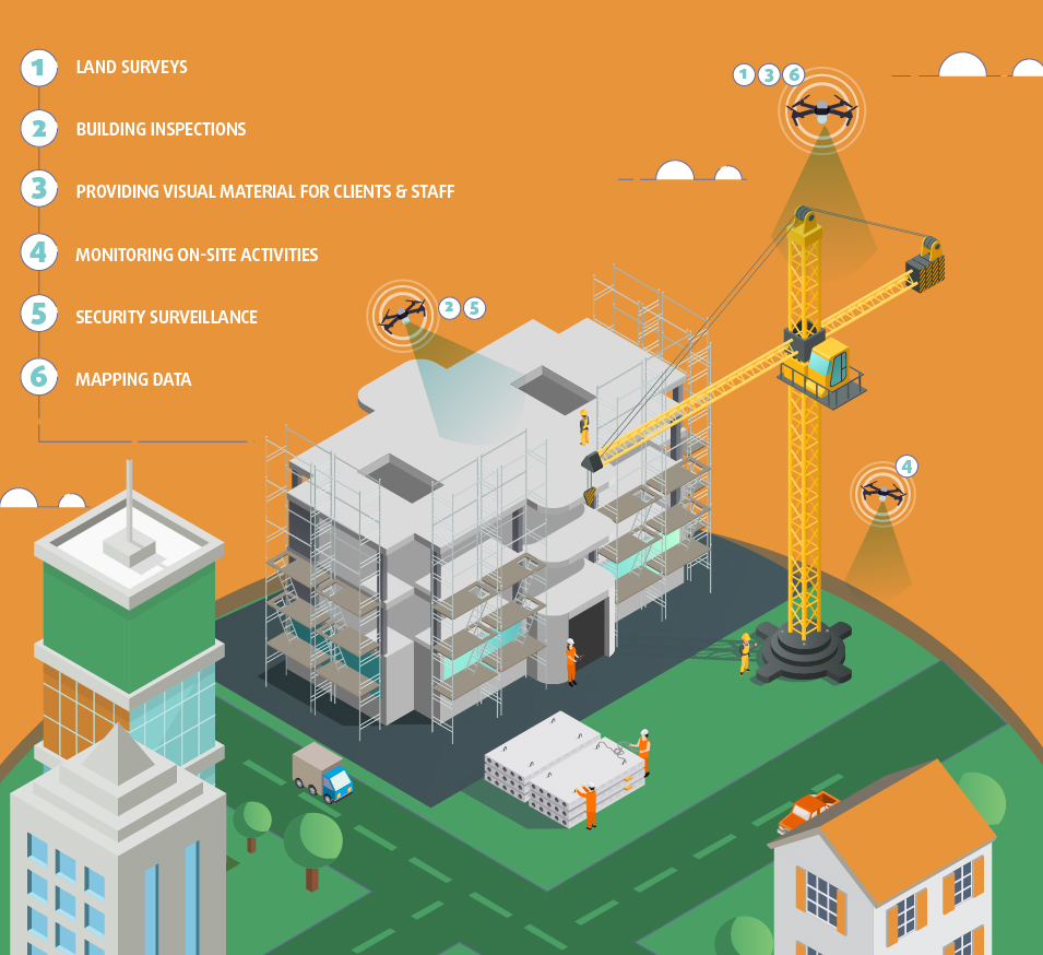
Use Drone Technology To Benefit Every Step Of The Way
Project managers, job superintendents and safety coordinators have more than enough on their hands when it comes to periodic inspections, jobsite progress monitoring and keeping everyone safe on the job while focusing on delivering their projects on-time and under budget. If a service or product could cost effectively eliminate or reduce the time devoted to daily, weekly and monthly tasks to support these efforts and reduce rework and risk, you would jump at the opportunity to be more efficient, right? Inspections are not the only way in which drone mapping benefits construction companies.
Pre-Construction – Site Surveying – Progress Monitoring – Material Inventory Management – 3D Mapping – Stockpile Measurement
This Is The Future Of Construction.
Construction is one industry in which the benefits of drone implementation is undeniably key to achieve the highest levels of efficiency and safety.
Your Bid Planning And Pre Construction
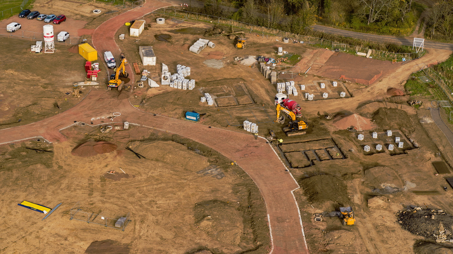
- Fly a site survey before breaking ground to capture initial state.
- Have 3D maps of the site available for your clients.
- Take advantage of the high accuracy data of drone mapping surveys to help make sure downtime is minimized and scheduling is on track.
- Be the company with data available that makes you stand out and so create an edge.
Easily see if your project is on schedule.
3D Mapping And Models
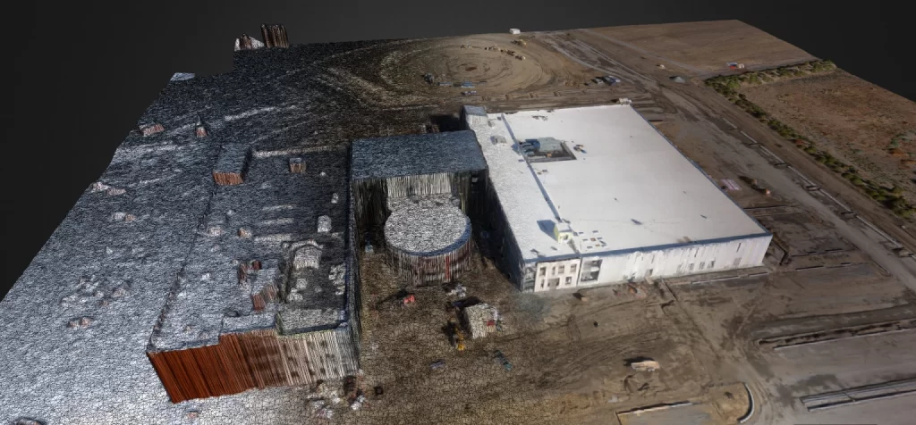
Turn data into 3D models to provide investors with a realistic look at the project. While construction is under way, the 3D models provide great benefit. 3D models during construction are used to measure scheduling compliance. Comparisons can be made regarding the existing work and the projected work, and these will indicate whether the work is consistent with the projections. The models demonstrate progress very well when generated through out the entire construction process.
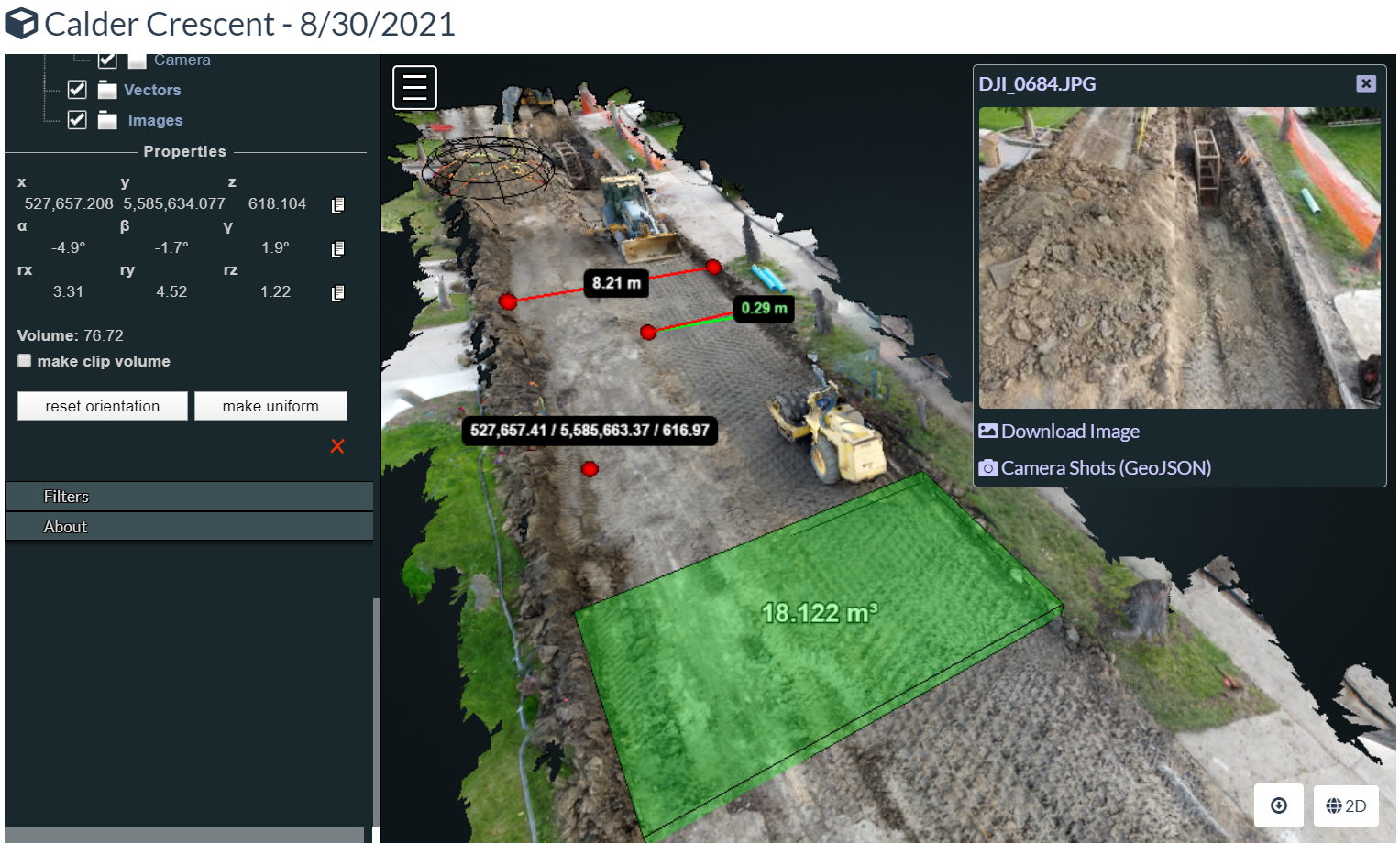
3D Models For Measurement Confirmation
The drone mapping photographs used in 3D modeling are Georeferenced. With this data, you are able to use the models to confirm measurements and requirements. In this model we have measured Volume on a flat plane, added a geolocated point, Measured height, measured length and measured a stockpile volume. By clicking on a camera point, you are able to see the original high resolution picture of any spot on the model.
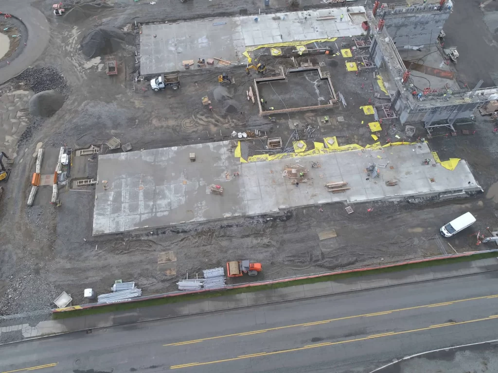
Progress Monitoring With Drones
Using drone mapping for progress monitoring, investors get a comprehensive view of the job site, from planning to completion. In addition to improved communication, there are several additional benefits of using drones for construction project monitoring:
Improve Safety
As drone mapping images are returned to you as a site survey, you can see where there are unsafe locations or areas of the build that may not be in compliance with building regulations. Seeing these issues as soon as possible or before an official inspection can save you time and money in repairing them down the road, and most importantly, prevent a job site injury.
Stay On Schedule
By identifying any phase of the project that is getting delayed and monitoring your job sites, you will have the project intelligence to proactively take steps that will reduce rework that will negatively impact cost and schedule. The more information you have at your fingertips, the more control you have over your project ultimately.
Improve Communication
With so many different types of contractors coming in and out, site condition changes, weather changes, and more, it becomes vital to keep an eye on the big picture. And drone photographs provide that big picture view. The aerial view gives the team a different, valuable perspective. Supervisors can sit down with a high-resolution drone map and quickly catch or anticipate any site access issues, potential drainage problems, or threats to health and safety. Then they can more effectively communicate with their team about site issues and resolve them.
Volume and Stockpile Measurement
Stockpile measurement and management plays an important role in many industries; from agriculture to construction. Traditionally, stockpile measurement has always been a labour-intensive job. Workers clambering across stockpiles on dangerous sites, putting their lives at risk while gathering data that isn’t always reliable. Enter accurate drone stockpile measurements, safely done in a fraction of the time.
Commercial drone technology is the future for this particularly troublesome task. From faster analysis speeds, greater accuracy and improved safety, the benefits of using drones for stockpile management are significant.
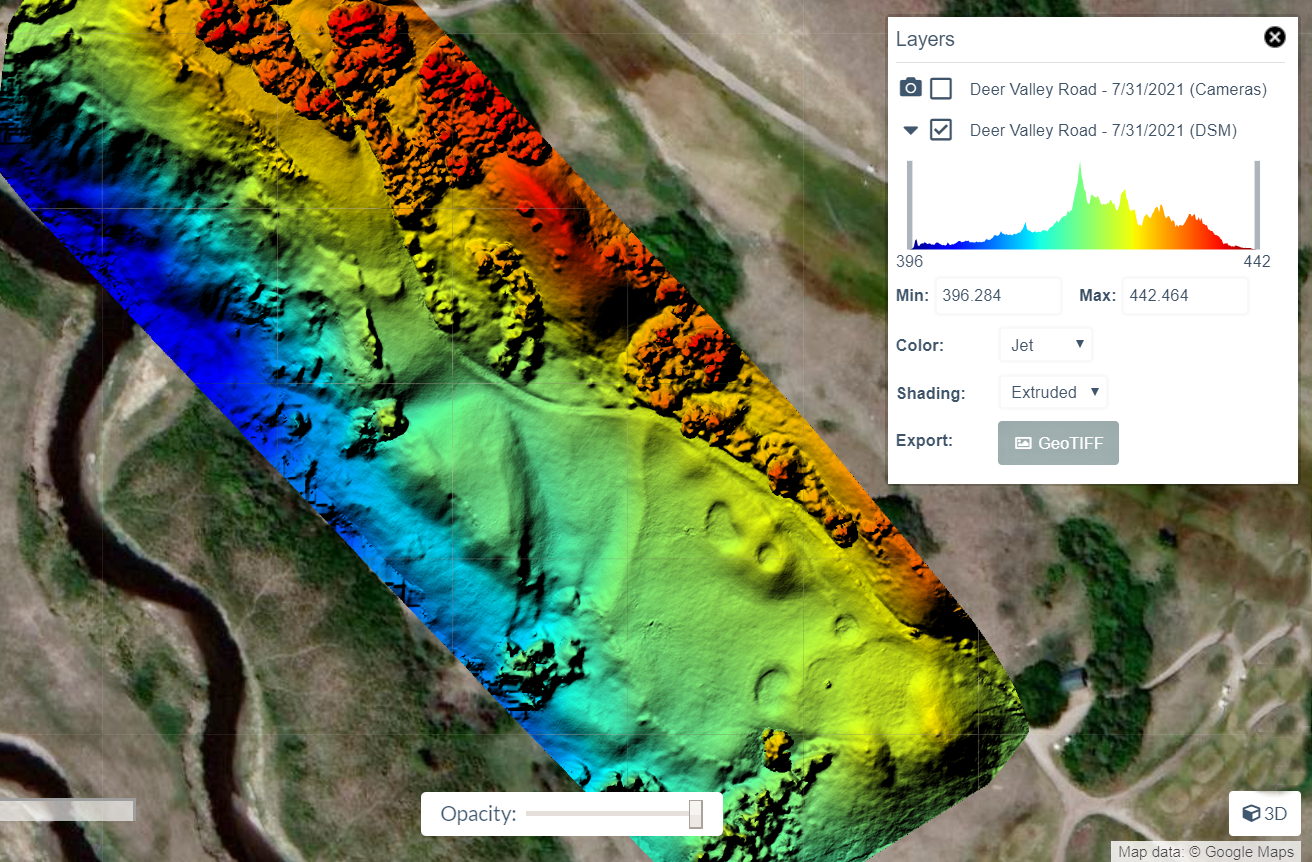
Digital Surface Models using Drone Imagery Helps Construction Planning
The Georeferenced Photographs and the point cloud created with them, make it possible to create extremely useful Digital Surface Models (DSM’s). A golf course construction and remodel project can make use of the elevation and contour information to both plan the physical layout and also considerations for irrigation and requirements. Construction projects can use such information to plan drainage and landscaping. These models can also help planners see how their project could impact surrounding area’s.
Stakeholders Know The Status, Always!
From the smallest to the largest projects, it is important to communicate within and between participating contractors. Every manager of each participant can see detailed visual updates. With this fantastic insight, planning for your companies effective allocation of your workforce is made more efficient.
Drone Construction Site Progress Report Video
This video is an example of what you can expect from drone progress reports provided by Libitron Aerial Drone Services.
- Progress reports are performed in logical intervals.
- Progress reports include high resolution video for easy to picture over all progress.
- You can choose: orthomosaic photographs, Volumetric measurements of stock piles, Digital Surface Models, 3D models or most any other type of data you may require.
- Media is delivered in a cloud based format so that all interested parties have access.