Western Canada’s Leading Edge Drone Service Company
Libitron Aerial Professional Drone Services specialize in data acquisition, drone mapping and inspection services.
Why Choose Libitron
Libitron Aerial Drone Services started operations in Regina, Saskatchewan. We now provide services all through Saskatchewan, Alberta and British Columbia with offices in Edmonton and Regina. Western Canada is home to some of the most vast farm lands in the world and the geography is full of hot beds for Oil and Gas, Wind Farming, Solar Sites and fast growth Construction. These are all industries in which drone technology greatly contributes.
Our commitment to excellence and experience will provide you with quality deliverables.
From basic to complex jobs done right. No other Drone Service Company is more responsive and offers a higher level of Customer Service than Libitron Aerial. No matter what your project may be, we are there to help you get the most benefit from Drone Services from the beginning to the end of a project. We offer improved efficiency versus working with disparate individual pilots or companies for your Aerial Photography Services. All drone mapping and inspection services will be executed by an advanced licensed pilot/pilots and in compliance with Canadian Aviation Regulations (SOR /96-433).
Operations By Location
For Details Follow Icon Links.
Drones In Construction
Construction Site Mapping – Canada wide
Construction Site Inspections – Canada wide.
Construction Progress Reporting – Saskatchewan, Alberta, Manitoba.
Drone Site Survey and Material Inventory Management – Saskatchewan, Alberta, Manitoba.
Drones For Infrastructure and Utilities
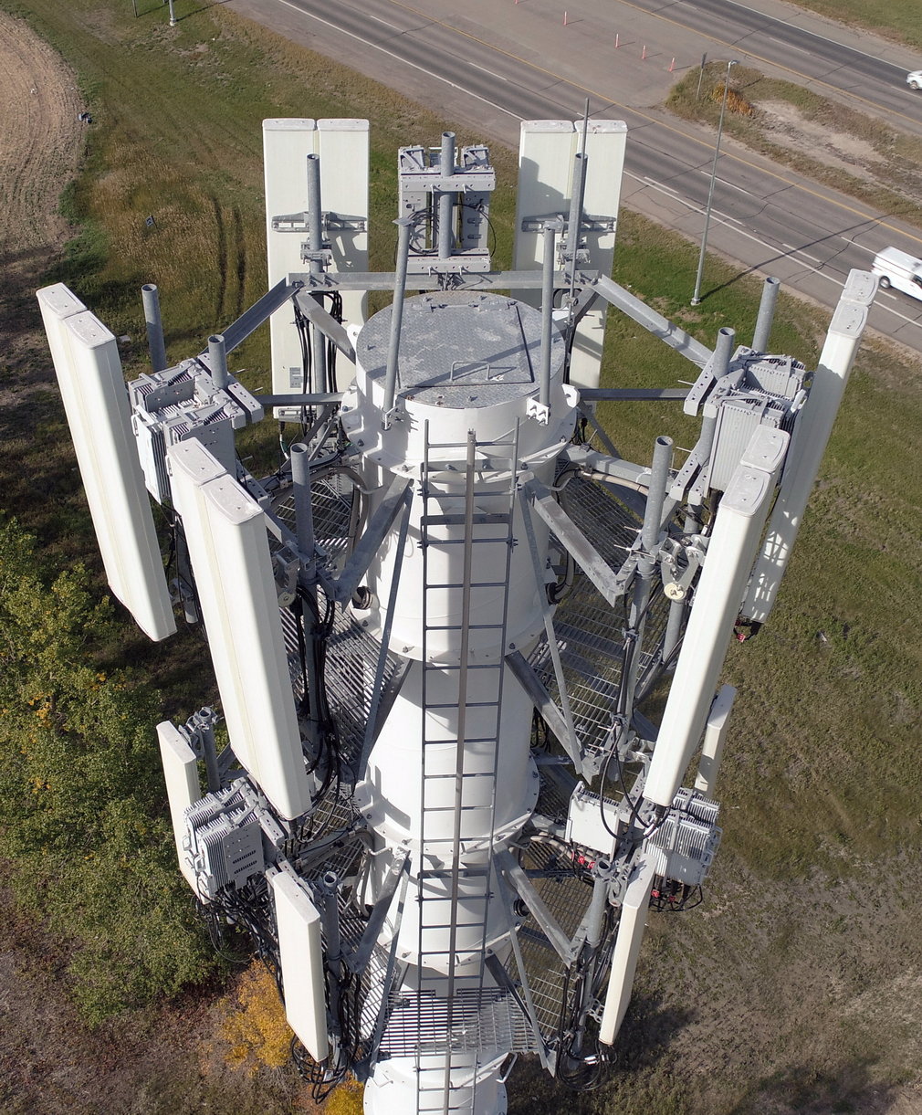
Drone Cell Tower Inspections – Saskatchewan, Alberta, Manitoba, British Columbia.
Drone Solar Inspections – Saskatchewan, Alberta, Manitoba, Ontario.
Drone Electric Inspection and mapping- Saskatchewan, Alberta, Manitoba.
Drones in Agriculture
Agriculture Drone Mapping for Precision Agriculture – Saskatchewan, Alberta, Manitoba, British Columbia, Ontario.
Multispectral Drone Imagery – Saskatchewan, Alberta, Manitoba, British Columbia, Ontario.
Artificial Intelligence based prescriptions – Saskatchewan, Alberta, Manitoba, British Columbia, Ontario.
Drones For Insurance
Aerial Natural disaster Monitoring – Canada wide.
Drone Insurance Inspections – Saskatchewan, Alberta, Manitoba, British Columbia.
Drone Insurance Risk Assessment – Saskatchewan, Alberta, Manitoba, British Columbia.
Insurance Claim Adjudication- Canada wide.
Drones For Oil And Gas
Aerial Site & Infrastructure Monitoring – Saskatchewan, Alberta, Manitoba.
Drone Production Equipment Inspections – Saskatchewan, Alberta, Manitoba.
Drone Site Preparation Orthomosaic Mapping – Saskatchewan, Alberta, Manitoba.
Drones, or unmanned aerial vehicles (UAV), are a rising trend among many industries. Today, the impact of drone technology on the digital transformation of the construction industry is undeniable. What started as a recreational toy or novelty camera has quickly become a competitive advantage for those willing to deploy it to their benefit. See the benefits of drone mapping and inspections in construction.
The Future Of Agriculture
Drones have revolutionized agriculture by offering farmers major cost savings, enhanced efficiency, and more profitability. By quickly mapping vast stretches of farmland, drones can map the property, report on crop health, improve spraying accuracy, monitor livestock and irrigation systems, and more. Find out how we can help support your Precision Agriculture goals.
Inspections
By using a drone to collect visual data on the condition of an asset, drone inspections help inspectors avoid having to place themselves in dangerous situations. You will maintain a real time and ongoing record of asset status. Inspections can be a part of planning, maintaining, risk assessment and pre and post loss claims. Drone Inspections help keep your assets safely up and running.
NOW WITH OFFICES IN EDMONTON AND REGINA.
Drones ARE an integral part of the future for a vast number of industries.
Contact Us to learn About What Valuable Data Drone Mapping And Drone Inspections Can Provide You.
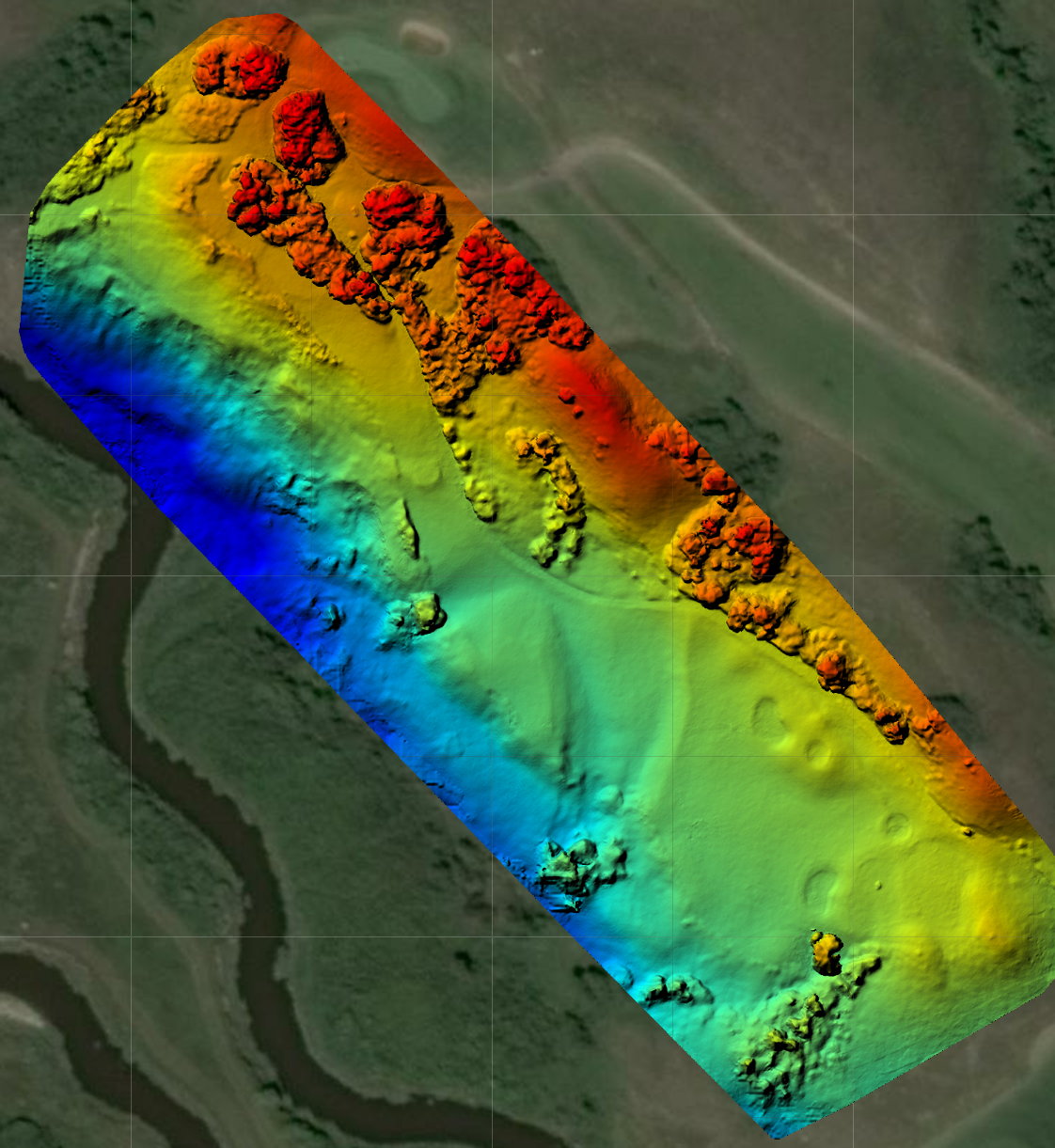
Drone technology is moving fast as we come to realize the unique views and data acquisition possibilities. Here we have a Digital Surface Model (DSM) so the golf course manager can better understand elevation and contours to assist in irrigation scheduling and focus.
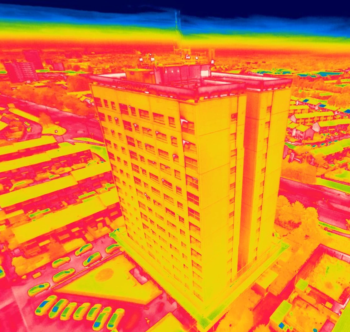
Drones are great for visual inspections. They are also extremely versatile because they can be fitted with many payload types of lenses like thermal and multi-spectral sensors.
Using Drones for Infrastructure inspections (Cell Towers, Wind Power, Electrical Installations, Oil & Gas, Solar Farms) keeps people out of dangerous situations, saves a tremendous amount of time, cost and provides repeatable data.