Precision
Agriculture
Benefits Of Agriculture Drone Services And Mapping
- Optimize the use of inputs (seed, fertilizers, water)
- Provide data on soil fertility and refine fertilization by detecting nutrient deficiencies.
- Forecast yields more accurately
- Count plants and determine population or spacing issues.
- Identify and react more quickly to threats (weeds, pests, fungi)
- Improve variable-rate prescriptions in real time
- Higher quality and more reliable imagery than satellite
- View damage to crops from farm machinery and make necessary repairs or replace problematic machinery.
We don’t have to tell you that the vast landscape of Canada provides one of the most important agriculture opportunities on our planet. Canadian farmers are known and respected for inspiring and making the most of innovation and technology. Agriculture Drone Mapping Services are one of the most impactful technologies of current generations. Properly used, the technology WILL help get more out of the land and at the same time reduce depletion. Libitron Aerial has been proudly serving Saskatchewan farmers in addition to time spent with the good people in Alberta and Manitoba.
Spray Drones - Fantastic Tools For a Farmers Toolbox.
DJI has led the way developing a tool to solve a challenge. Originally designed for the very hard to reach area’s in Asia, the spray drone has developed into what is now an impactful tool for any farms operations. Rocky Mountain Drones in Alberta is a company which has embraced bringing this technology to market. There is a tremendous amount of information discussing benefits of the technology easily found with any Google or Facebook search.
We thought it would be interesting and worthwhile showing you the video they recently produced for YouTube. It is unique in that it follows a couple weeks of providing demonstrations with the new DJI Agras T50 Spray Drone to customers. We hope you have a look and enjoy. Feel free to submit any questions about the video in it’s comments or contact us. Compliments of rockymountaindrones.ca
What Is Precision Agriculture?
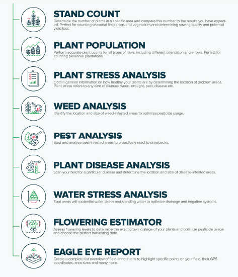
Crop monitoring from the sky using agricultural drone mapping is a great way for farmers to gain effective crop insights and the latest agricultural drones have a wide range of features. Firstly, mapping systems give farmers the power to analyze their crops and gain valuable data to guide decision-making. In addition, drone devices can capture clear images of the crops from an aerial view.
What’s more, farmers can proactively schedule and target various crop monitoring treatments such as fertilizer applications. These images along with the mapping system, ensure farmers are informed about irrigation, soil, and infestation dilemmas.
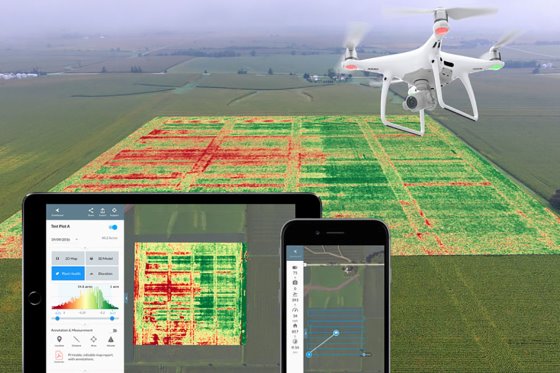
Multi-Spectral Imagery
Multispectral images are a very effective tool for evaluating soil productivity and analyzing plant health. Viewing the health of soil and crops with the naked eye is very limited and is reactionary. Multispectral sensor technology allows the farmer to see further than the naked eye.
Three of the most common images that provide insights into crop variability are color (RGB), near-infrared (NIR), and normalized difference vegetation index (NDVI). A feature like NDVI imagery can determine crop health by measuring the index of crop greenness. This allows farmers to track crop growth in-season and make comparisons.
What Can You Expect From Drone Imagery?
It’s simple. The information provided will demonstrate exactly what state your plant health is in. You will learn:
- If the crops are healthy or stressed.
- You will be able to determine exactly what is causing the stress condition, whether it is too wet or dry and how you could improve those conditions.
- Do you have infestations?
- Do you require pesticides or fertilizer?
- You will be ale to more accurately estimate yield.
- You will be in control like never before.

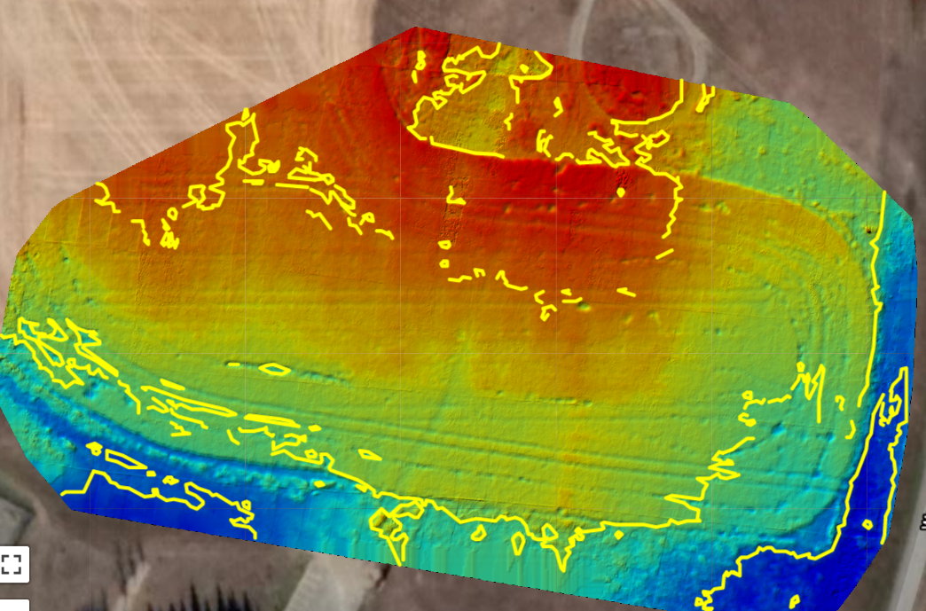
A More Informative Perspective
Orthomosaic photos offer the full picture. In the photo above (taken in Regina, Saskatchewan) the field seems healthy looking as you drive along and scout from the access roads. The drone perspective insures that you have the best chance of spotting stressed areas and seeing geographical areas in need of attention for work like drainage.
– Wikipedia.com
Digital Surface Models (DSM) And Contour Maps
– A DEM (Digital Elevation Model) Represents the bare-Earth surface, removing all natural and built features.
– A DSM (Digital Surface Model) captures both the natural and built/artificial features of the environment.
– A DTM (Digital Terrain Model) typically augments a DEM, by including vector features of the natural terrain, such as rivers and ridges. A DTM may be interpolated to generate a DEM, but not vice versa.
The Digital Surface Model (DSM) above helps derive canopy height as well as elevation effects on the field. Some of the benefits of implementation of DSM acquired from drone agricultural mapping:
Farm contour design • Farmland suitability analysis • Drainage analysis • Conservation planning • Mapping of floodplains, Cultural resources, Wetlands, Grasslands, Forests, and Wildlife Habitat.
When combined with 3D Mapping, further benefits include:
Increased crop yield • Decreased crop losses due to flooding or poor site design • Improved compliance for the application of regulated chemicals • Reduced design costs for farm ponds and other farm infrastructure • Conservation of critical natural resources and habitats.
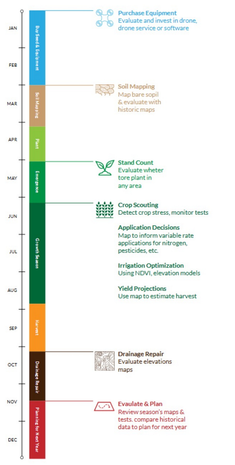
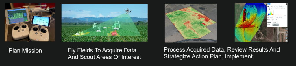
How The Work Flow Looks- Pre Seed To Harvest
Make A Plan
Libitron Aerial meets with you to discuss your goals and needs regardless of where you are in Saskatchewan, Albert or Manitoba. Together we can identify how we can best contribute to helping achieve those goals. We are an organization that believes in “less talk, more do”, so lets get to work!
If working with us is your first time working with drones we will suggest:
Starting with some video scouting. Whether we have started working together pre-seed or part way into the growing season, we can benefit by a visual over view of your land.
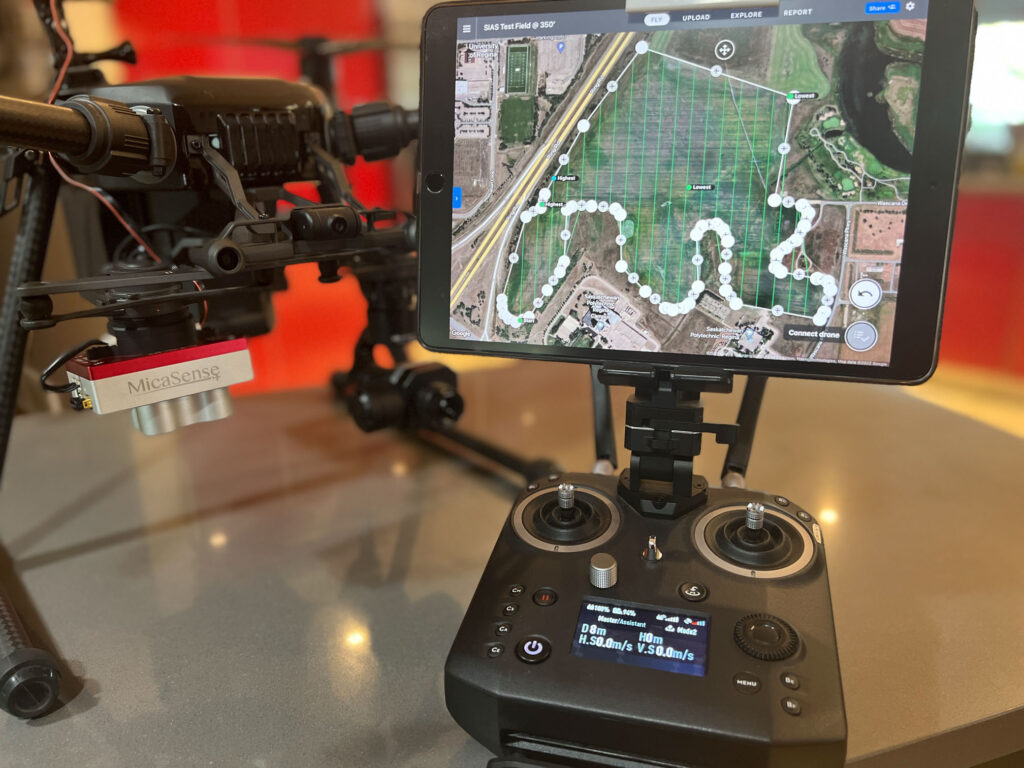
Basic Deliverables From A Mission
Basic information, which in many cases, can be produced immediately are the deliverables mentioned above. This would include the orthomosaics, Digital Surface Models and NDVI imagery. We can decide together which stages of growth that it would make most sense to fly for your operation.
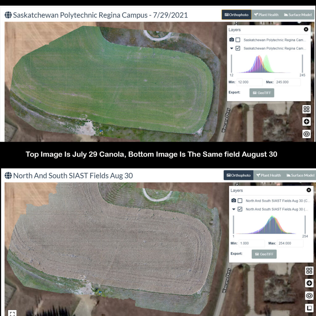
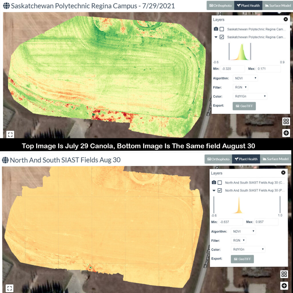
Tracking How Your Field Performs
The following is an NDVI and OrthoMosaic comparison of a Canola field just outside of Regina. The first image from drone agricultural mapping was taken July 29 and the second August 30. The information helps determine the success of treatment and also in determining optimal harvest timing.
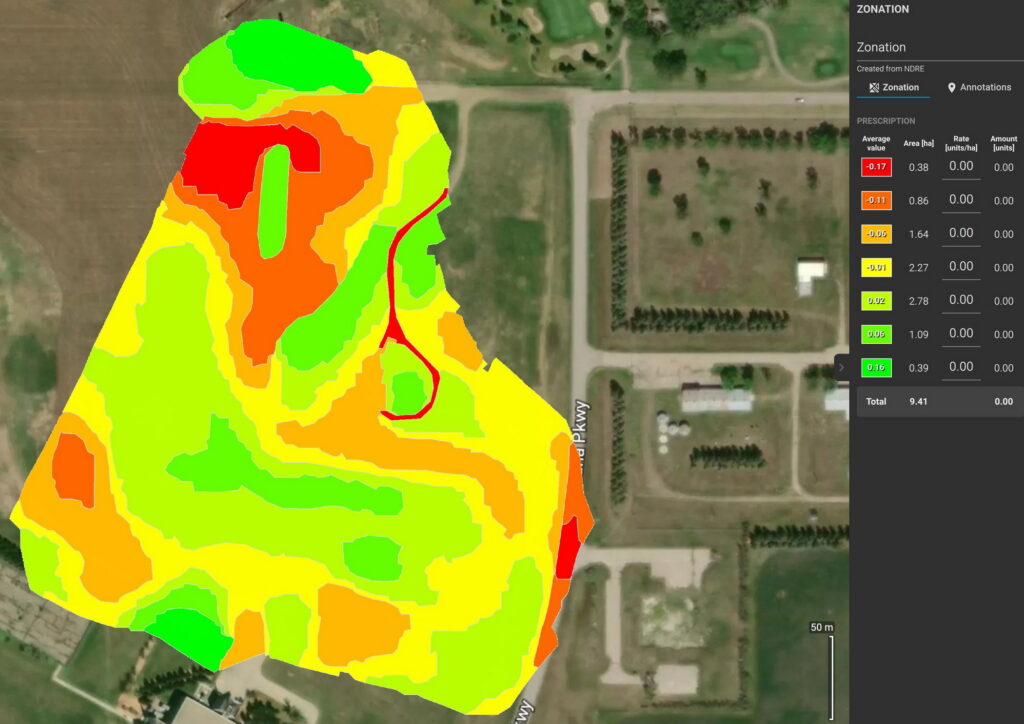
The Icing On The Cake - Geo-Referenced Zonation Maps
The map produces zones bases on index values. An NDVI map was created for this wheat crop. The multispectral data was captured on June 22 of the growing season. Zones are representations of the GAI. With this data the amount of fertilizer required can accurately be calculated for each zone. The farmer may make their own decisions, work with an agronomist or even use AI to determine application rates. The zonation could even have more sections for even tighter variable application decisions. You can see how waste is greatly eliminated.
Similar zone maps can be created to identify where weeds may be, pests may be and even help determine irrigation practices.
Optional But Critical Considerations - AI Analysis.
Going A few Steps Forward With Analysis and prescriptions.
Libitron Aerial has done the ground work to develop relationships with organizations and individuals which excel in each area of drone technology implementation into precision farming. Many farmers will be satisfied with the basic results provided by drone agricultural mapping and the data provided as we discussed above. The number of farmers going a step farther is now increasing. The past year has seen extreme growth rates in Artificial Intelligence driven analysis and prescription options, all accessible through Libitron Aerial.
If You Could See And Use All Of this Measurable And Actionable Analytic Data, How Would Your Yield And Profits Look?
Lets Make A Plan!